Mount Marapi, Galogo & Lava, and Tips for Dealing with Them
Education


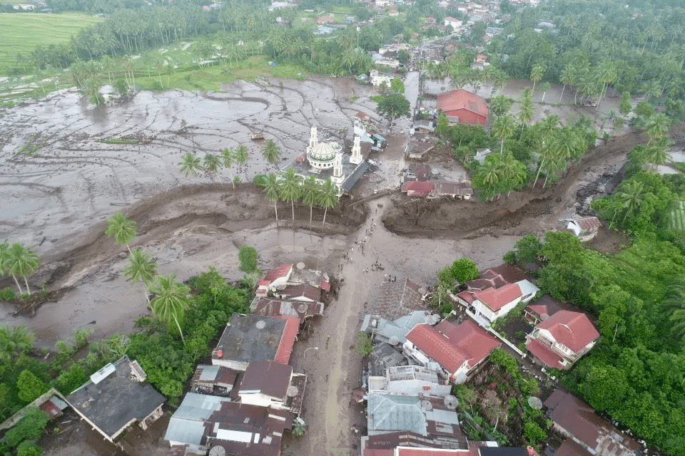
BPBD Tanah Datar drone monitoring of flash floods at Simpang Manunggal, Lima Kaum District, Tanah Datar Regency. The river has its head at Mount Marapi with the name Malana or Lona River (BNPB)
MKPI Education – The National Disaster Management Agency (BNPB) announced that the number of victims who died due to galodo/flash floods in several areas of West Sumatra (Sumbar) had reached 41 people. This flash flood material comes from Mount Marapi which has been active for the last two years. Abdul Muhari, Head of the BNPB Disaster Data, Information and Communication Center, stated that the victims were spread across several areas, with 19 people in Agam Regency, 15 people in Tanah Datar Regency, and 7 people in Padang Panjang City. This incident should be of concern to all parties. The question that arises is why did this galodo happen and why did this incident recur?
Flash Floods, Galogo, and Lava Floods
Flash floods are floods that come suddenly with large water discharges caused by the blocking of river flows in river channels (Law Number 24 of 2007). Flash floods occur some time after heavy rain (in the range of several minutes to several hours) which occurs for a short time in some watersheds or narrow river channels upstream. Flash floods are also called galodo, a local name in West Sumatra.
Lahar flood is a general term used to describe a mixture of flowing water and debris (debtis) of volcanic material. Lahar is divided into two types, namely (1) ‘Primary’ or ‘syn-eruptive’ lava: If it occurs simultaneously with, or is triggered by, primary volcanic activity and will produce hot raining lava. (2) ‘Secondary’ or ‘post-eruption’ lahar: If it occurs without primary volcanic activity, for example as a result of rainfall during a lull in volcanic activity and will produce cold raining lava (Indonesian Magma).
Mount Marapi has experienced eruptions several times and was recorded in 1830, 1979, 2011, 2014, 2023 and 2024. Since the beginning of 2023, Mount Marapi has shown its activity, in fact, throughout 2024, Mount Marapi has erupted 170 times. As of Monday morning, April 29 2024, at 06.00 WIB, Mount Marapi is still on Alert status (Level III). This means that a lot of loose material from the eruption has accumulated around the tops of the upper slopes and at any time can come down as a flood of rainy lava. In connection with the activity of Mount Marapi, a map of danger-prone areas (KRB) has been issued, including rivers that originate at Mount Marapi, which are prone to lava floods (KRB I).
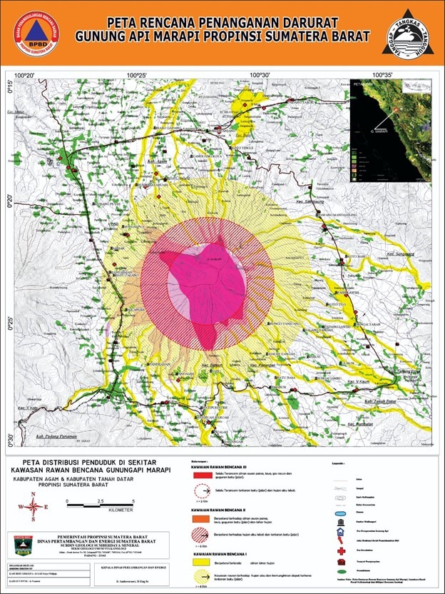
Mount Marapi Risk Map, West Sumatra
Risk of Flash Floods Mixed with Mountain Lava
The Meteorology, Climatology and Geophysics Agency (BMKG) revealed that the intensity of very heavy and long-duration rain was the main trigger for flash floods mixed with mountain lava that hit three districts/cities in West Sumatra. The BMKG Meteorological Team issued an early warning of potential extreme weather which could trigger hydro-meteorological disasters such as floods, landslides and so on in West Sumatra. It was recorded that on Saturday, May 11 2024, rain fell from afternoon to evening above 150/200 mm. As a result, flash floods followed by lava hit Agam Regency, Tanah Datar and Padang Panjang City.
Based on BMKG analysis, he continued, until May 13 2024 there is potential for rain with moderate to heavy intensity. Meanwhile, on May 14, it is predicted that the intensity of the rain will decrease to light, then on May 15-17 2024 it is predicted that there will be another increase in rainfall until May 22 2024. This means being alert to the occurrence of rain lava floods, as well as galodo or flash floods and landslides. This will continue at least until May 17-22 or the next week. So, people are advised to avoid or stay away from hillsides or mountains that are prone to landslides.

Heavy equipment removed rock material caused by galodo from Mount Marapi in the Simpang Bukit Batiuah area on Friday (21/5) (Documentation by BNPB)
Tips for Dealing with Threats
It is recommended not to live in the KRB I area, namely on the river and surrounding banks. Remember that active volcanoes will always emit rocks, sand, ash and lava. This means that if there is a trigger for rain, the material will become a galado carrying material (debris). The first flash flood will cause the river to be covered with volcanic sediment and during the second flood and so on it will overflow and hit the settlements on the riverbanks. It is not recommended to live in the KRB I area.
It is highly recommended for the government developing tourism in the KRB I area to create an early warning system installed in the upstream and middle areas. The hope is that people who carry out tourism activities upstream can be informed early and immediately evacuate to save themselves.
Author: Dr. Ir. Amien Widodo, M.Si.
Latest News
-
MKPI ITS and JSCE Discussion: Reverse Zoning to Enhance Disaster Resilience
MKPI Education – On November 18, 2024, Institut Teknologi Sepuluh Nopember (ITS) Surabaya, together with the East Java Regional
-
Mount Marapi, Galogo & Lava, and Tips for Dealing with Them
MKPI Education – The National Disaster Management Agency (BNPB) announced that the number of victims who died due to
-
Learning from the Jogja Earthquake of 27 May 2006
MKPI Education – Eighteen years ago, precisely on May 27 2006 at 05.53, an earthquake measuring M5.9 lasting less