ITS Researchers Respond to Landslides and Disasters in Sukabumi

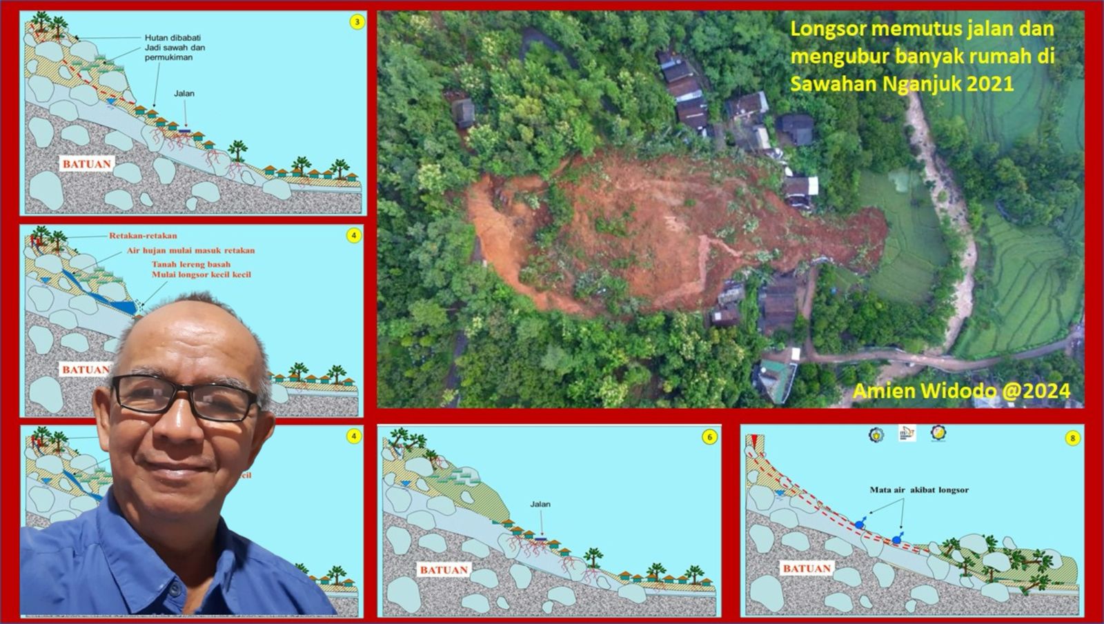
ITS senior researcher Dr Ir Amien Widodo MSi explained about landslides due to changes in land on the left and right of the road that cuts the mountain slope.
ITS Campus, ITS News — The extreme weather that has hit recently has caused various disasters in several regions of Indonesia. One of them that has just hit Sukabumi, West Java is a natural disaster of moving soil, flash floods, and landslides, last December 4, and caused 215 families or 712 people to have to evacuate to safer locations.
Senior researcher from the Center for Disaster Mitigation and Climate Change Research (Puslit MKPI) Institut Teknologi Sepuluh Nopember (ITS) Dr Ir Amien Widodo MSi explained that the phenomenon of moving land in Sukabumi was caused by various factors. One of them is changes in land use in mountainous areas. These changes do not occur suddenly, but rather through a long process that has been going on for decades.
One of the most striking forms of change occurs in the land on the left and right sides of the road that cuts the mountain slope. Initially, the slope was cut for road construction, which directly disrupted the stability of the slope due to the increased angle of inclination.
Furthermore, settlements began to appear around the road, both on the left, right, above, and below the road. Residents often clear land by cutting down trees, so that the soil cohesion decreases. This condition is exacerbated by the cutting of slopes for the construction of houses, which further increases the angle of inclination of the slope and makes its stability increasingly critical.
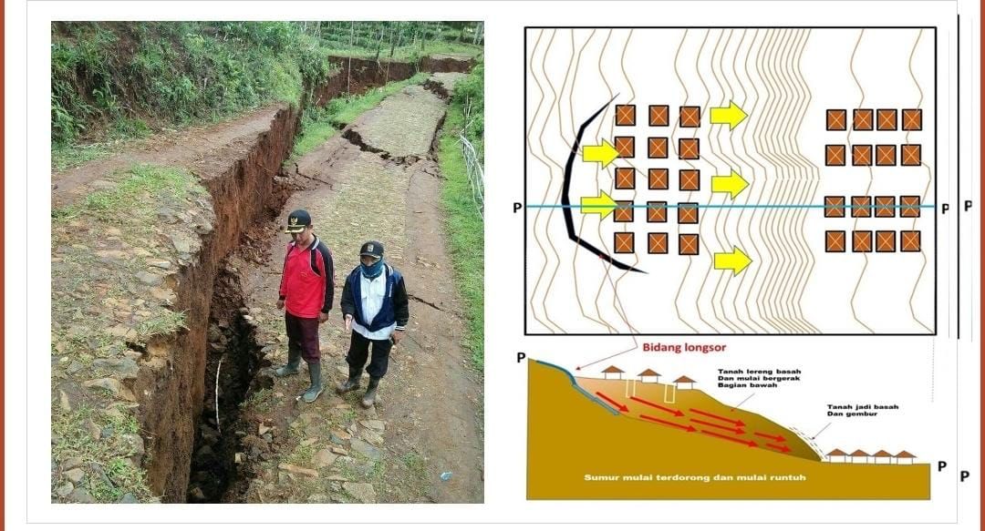
Amien also explained that the increasing number and weight of buildings around the slope contribute to the increase in soil mass which worsens the condition. Cracks will appear that are wider, more numerous, and the soil will sink further. “This is what laypeople usually call land subsidence,” he added.
This ITS geology expert also highlighted the extreme weather phenomenon due to global warming which ultimately worsens the condition. Global warming increases the intensity of rain, wind, and sea waves. This impact can be seen in the La Niña phenomenon which causes rainfall to increase by up to 20 percent higher than usual. “High rainfall like this is the main trigger for landslides,” explained Amien.
Furthermore, Amien explained, the most significant change can be seen from the topography of Sukabumi which is now experiencing changes due to human activity. The area that was previously a water catchment area has now changed function. As a result, rainwater cannot be optimally absorbed into the soil, but flows as surface water which triggers erosion, flooding, and landslides. “This process accelerates land instability, especially in areas with many hill cuts,” explained the lecturer from the ITS Department of Geophysical Engineering.

Landslides, flash floods and landslides hit the Sukabumi area, West Java
To overcome this problem, Amien suggested returning the function of the forest on the hilltop. According to him, the area should be conserved and not used for human activities. This step will help maintain ecological balance and reduce the risk of disasters in the future. “We need to recalculate the absorption capacity and water flow in the area,” he reminded.
Regarding disaster mitigation, Amien assessed that the government’s efforts were actually quite good, especially in compiling maps of disaster-prone areas. However, he emphasized the need for further action to educate the public and provide concrete solutions in vulnerable areas, such as immediately evacuating residents around the cracked land area until repair steps are taken.
Not only that, this disaster mitigation expert also highlighted the need for stricter spatial planning regulations. Amien suggested cross-ministerial collaboration to formulate policies that can prevent further environmental damage. “This is the time for various parties to sit together to address this problem in an integrated manner,” he said.
Amien also reminded the public to be more alert to early signs of land movement. Cracks in the ground, houses that are starting to tilt or crack, and shifting electricity poles are some of the indicators that need to be considered. “If these signs are seen, residents are expected to immediately evacuate to a safe location,” he said.
Amin also reminded the public to be more alert to early signs of land movement. Cracks in the ground, houses that are starting to tilt or crack, and shifting electricity poles are some indicators that need to be considered. “If you see these signs, immediately report them to the authorities such as the local BPBD so that an assessment can be carried out immediately and evacuation can be carried out if necessary,” Amien advised.
Although Sukabumi is the main focus of the affected area, Amien reminded that similar disasters can also occur in other areas in Indonesia. With tropical climate conditions, most areas in Indonesia are vulnerable to hydrometeorological disasters such as floods, landslides, and flash floods. “Through proper regulations and good public education, the impact of disasters like this can be minimized,” he concluded. (ITS PUBLIC RELATIONS)
Reporter: Lathifah Sahda
Related News
-
ITS Wins 2024 Project Implementation Award for Commitment to Gender Implementation
ITS Campus, ITS News —Not only technology-oriented, Institut Teknologi Sepuluh Nopember (ITS) also show its commitment to support gender
December 11, 2024 14:12 -
ITS Professor Researched the Role of Human Integration in Sustainable Architecture
ITS Campus, ITS News –The developing era has an impact on many aspects of life, including in the field
December 11, 2024 14:12 -
ITS Sends Off Group for Joint Homecoming to 64 Destination Areas
ITS Campus, ITS News — Approaching Eid al-Fitr, the Sepuluh Nopember Institute of Technology (ITS) is once again facilitating academics who want
December 11, 2024 14:12 -
ITS Expert: IHSG Decline Has Significant Impact on Indonesian Economy
ITS Campus, ITS News — The decline in the Composite Stock Price Index (IHSG) by five percent on March 18,
December 11, 2024 14:12
