ITS Develop The Use Of AIS Technology For Maritime Safety
End-to-end based cargo ship tracking system developed by AISITS
ITS Campus, ITS News – Institut Teknologi Sepuluh Nopember (ITS) always pays attention to the field of work that continues to develop its science. In order to prepare future maritime challenges, Together with leading institutions from abroad, ITS will develop the utilization of Automatic Identification System (AIS) technology to maintain maritime safety.
It was presented in the webinar of the Maritime Safety International Conference (MASTIC) on Saturday (18/7). Themed Responding to Future’s Technological Challenges and Opportunities in Maritime Towards Safety Operation at Sea and Environmental Protection, focusing on maritime safety, is presenting three keynote speakers, Prof Dr. Ketut Buda Artana ST MSc from Indonesia, Prof Dr. Serdar Kum from Turkey, Prof Adi Maimun bin Malik FRINA CEng from Malaysia.
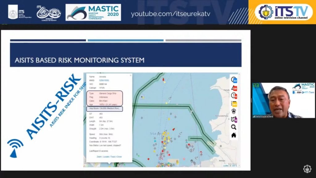
Prof Dr. Ketut Buda Artana ST MSc as ITS explained the use of AIS at ITS called AISITS. AIS or the Automated Identification System is an automatic tracking system used on ships and by ship traffic services to identify and locate vessels. ITS developing AISITS in two forms, in Web applications, and mobile applications. “AISITS used in ship management at ports, ship safety management, fuel monitoring, to monitor the potential of ship emissions, management of vessel inspections, and others,” said the lecturer who familiarly called Ketut.
The Alumnus of Newcastle University, UK explained that the AISITS project has been developed since 2007 and cooperated with Kobe University, Japan. Then, the project continued until the development of algorithms by the Ministry of Research, Technology, and Higher Education at that time until it was successfully launched in 2018. “In 2018, AISITS managed to be downstream by ITS Tekno Sains,” said the lecturer of the Statistics Engineering course.

Prof Dr. Ketut Buda Artana ST. MSc as speaker from ITS in the MASTIC webinar 2020
The way the AISITS works is not much different, AIS will send signals from the main station and will be translated into raw data. Furthermore, the data will be combined with other data such as coordinates, scientific analysis, and basic ship data. The Data that has been incorporated will be transferred in the form of an early warning system and distributed by electronic mail, large screens, vessels, and mobile devices.
Ketut reveals the utilization of the AISITS is already used in several studies, such as ship tracking, fuel monitors, gas emission monitors, avoiding the voyage traffic accident, and the oil spill monitors. “AISITS latest research is the tracking of cargo ship-based end-to-end systems,” said Professor of Department of Marine Engineering who often publishes research related to the ship monitoring system.
With the webinar related to maritime safety, it is hoped that ITS will capable of creating innovations related to the shipping system and ship safety by utilizing existing and evolving AIS technology.
Not only ITS, Istanbul Technical University (ITU), and Universiti Teknologi Malaysia (UTM) also applied AIS technology in various operational systems. In the first discussion, Prof Dr. Serdar Kum, the Science and technology expert from Istanbul explained about the AIS Utilization project in maritime research and safety in Turkey.
Prof Dr. Serdar Kum from Istanbul, Turkey as a speaker in the MASTIC Webinar 2020
In Serdar’s description, the use of AIS can give you four key benefits of detecting the latest navigational risks with logarithmic analysis, computing data from the tracking tool tracing results, being able to integrate navigational devices and run vessels, as well as capable of running the ship’s evaluation process. “We will use Electronic Chart Display and Information System (ECDIS) and AIS through data recorder,” explained the Vice-Rector of ITU.
AIS provides four types of data: Statistical data, Dynamic data, related travel data, and related safety messages. An alumnus of Kobe University, Japan also explained how AIS works, where data will be received in NMEA format. NMEA is a standard data format supported by all Global Positioning System (GPS) manufacturers or satellite-based navigation systems. “Then, we will do the AIS encoding and separate the data, then translate the messages from the sent data and the ones to be used,” said Serdar in his presentation.
Furthermore, the encryption data of the AIS will be read and will be extracted from the chart in the form of coastlines, depth of area, depth of contour, land, and water. The results of data encryption will be computed through latitude and longitude, the interval of distance the use is ten meters from this tool. “After that, we visualize the graph by displaying the graph data, shape, and dimension of the vessel, as well as the resulting risks,” said the marine transport technology expert.
Another speaker, Adi Maimun, exposes related use of AIS data in performance development and research in UTM. Adi takes case studies in Straits of Malacca which is one of the world’s cruise lines with more than 60,000 fleets operating annually. Thus, in support of maritime safety in the area, the 1983-born man revealed that the AIS facility was installed in UTM. “The AIS receiver is already installed at the UTM Observatory station and can accept the position, travel, speed, and identification of the vessel,” Adi explained.
The AIS works by capturing radar via frequency, then received by the receiver machine, and subsequently transferred to a maritime laboratory in UTM to be converted into Web pages and databases. The vessel’s dynamic structure describes the management, analysis, and visual consoles, where AIS presents maps of the Straits of Malacca and ships characterized by thicker lines. “The ships in the area are based on the base of the hour and there is a ratio of distance traveled with travel time,” he added.
Members of the Royal Institution of Naval Architects mentioned some of the risk assessment that AIS can provide. Among them are hazard identification, estimated likelihood and frequency of accidents, consequences of harm, qualitative assessment of maritime risks, and the identification that can be done to mitigate the dangers of such risks. “We collect data and we see what we can analyze,” said Adi in his presentation.
Speaker from Malaysia, Prof Adi Maimun bin Malik FRINA CEng in the MASTIC webinar 2020
AIS data is useful for anti-collision systems in the Straits of Malacca and estimates the emissions gases from ships, where data from AIS translates several things from ships i.e. relative speed, relative distance, identification of ship radio stations, etc. Adi presented how the data combined and the passing vessels were able to avoid collisions with the current data from AIS using Fuzzy logic. Cryptic logic serves to put input data into the output data.
This conference is expected to give knowledge of the great opportunities for the safety of cruise and maritime traffic. With AIS technology, maritime accidents and emissions of exhaust gases from vessels can be identified early.
Therefore, Ketut said, ITS will also continue to develop and strengthen the relationship with foreign institutions to cooperate in improving maritime safety as a form of community devotion.(jev/rev/ITS Public Relations)
Related News
-
ITS Lecturer Introduces Madurese Culture to the International Stage
ITS Campus, ITS News — Continuing to show local wisdom to the world community, this time a lecturer from the Department
July 22, 2020 16:07 -
ITS Researchers Remind TKDN is Crucial for Economic Independence
ITS Campus, ITS News — The Domestic Component Level (TKDN) is the key to restoring the glory of the Indonesian
July 22, 2020 16:07 -
Strengthening Quality Education, ITS Professor Develops Adaptive Technology for Students
ITS Campus, ITS News — Differences in students’ abilities in understanding lessons are often a challenge for teachers in the classroom.
July 22, 2020 16:07 -
ITS Graduates Create Reverse Logistics Model for PET Plastic Waste Recycling
ITS Campus, ITS News — Doctoral graduate from the Department of Industrial and Systems Engineering, Sepuluh Nopember Institute of Technology (ITS) Dr. Yuniar
July 22, 2020 16:07