Port on the North Coast of Central Java Prone to Sink
News-EN

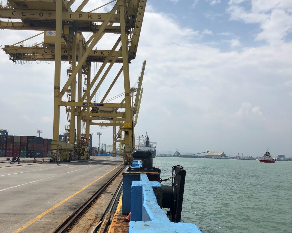
Port illustration on the north coast of Central Java (Source: personal documentation)
Coastal areas are very dynamic areas and have considerable potential resources. Its relatively flat morphological condition causes coastal areas to be easily accessible, thus expanding into an area’s economic center and also supported by large potential areas. However, coastal areas are also highly vulnerable to hazards such as floods, puddles, and land degradation. The impact of the disaster will be more widespread if it is not immediately handled appropriately.
Economic activity on the northern coastal areas of Java is dominated by the port. Port has a vital role in the area because it can be a support system for hinterland behind it. The port can be the gateway of an area because the whole flow of distribution of goods and people through the sea lanes will surely pass through the port. On the north coast of Central Java province, there are three ports in operation. It includes the port of Tanjung Emas, Port of Kendal and Port of Batang.
The three ports are under Pelindo 3 Central Java regional branches. One of the three ports is one of the main ports in Indonesia, the port of Tanjung Emas. Tanjung Emas Harbour serves not only the ship between islands, but it also serves ships originating from the international. Tanjung Emas Port is the third largest port after Tanjung Priok port and Tanjung Perak which is located in Semarang City, the capital of Central Java province.
Semarang City as the capital of Central Java province has unique geographical characteristics where Semarang region is divided into two, namely lowland in the north and Highlands in the south. The northern part of Semarang is a lowland on the north coast of Java Island. Industrial activities and urban public facilities such as office, trade, Services, education, health and transportation (Ahmad Yani Airport, Tawang railway station and Poncol, Tanjung EMAs Port and Terboyo terminal) are located in the area. While the southern part of Semarang is a hilly area, which is used as conservation land, residential areas, natural tourism, and education
In the last 40 years, Semarang has undergone a flood of Rob. This flood flooded several places in the coastal city of Semarang during the tide of sea water. It has been known to cause the rise of seawater due to the factors of global warming, change of land use, poor drainage system, and soil loss. The decline in land advance is the most dominant factor and a highlight in the efforts to mitigate the north coast of Java island, especially in central Java.
Land subsidence is the phenomenon of change in land level that lasts within a short or long period of uneven distribution in each location. The significant rate of land decline in Semarang varies between regions. In general, getting closer to the coastline, the rate of land decline will be greater. Where the largest rate of land decline is in the port area of Tanjung Emas (North Semarang) amounted 4-12 cm/year. Existing condition of land elevation that is lower than sea level, causing the greater rate of decline in land advance.
The decline of land advance has occurred in the city of Semarang and has been conducted a lot of research on this phenomenon. The city of Semarang has undergone this phenomenon more than 100 years ago. Proven by the expansion of coastal areas, cracks in infrastructure buildings, and increased inland water intrusion in areas affected by disasters. Another evidence due to the impact of land loss is by the elevation of the road that is followed by the elevation of the floor of the house that is around the road. If the elevation is continuous, the distance between the floors and the roof of the house is increasingly retractable. Not only Semarang, the decline of land also occurred in the city of Pekalongan, Demak District, West district of Kendal and some other areas along the northern coast of Java island.
This phenomenon certainly hurt the affected community. The social and economic losses caused by land decline resulted in a slight rob flood. In passing, the flooding that flooded the residents ‘ settlements and the shops of Kota Lama has reduced economic growth in the region. It is characterized by the growing number of shophouse units or abandoned buildings. The destruction of historical traces of ancient buildings of Dutch heritage as a cultural site that must be protected.
But the biggest disadvantage due to this phenomenon is felt by the port area, where the largest land decline is in coastal areas. This can be seen at Tanjung Emas Harbor Terminal in Semarang. On the Port Jetty area, built a wall with a height of about one metre as a barrier between the jetty and the sea. This wall was built because of the nearer distance between sea level and jetty. If there is no wall, the sea water will be flooded with the dock during the tide of seawater. Surely the water will interfere with the operational activities of the port. Not only build walls, docks and field buildup is also done elevation and equalization of land. Seen the new jetty has a height of one meter above the old jetty and there are several buildup fields that have been elevated.
Soil decline resulted in differences in ground height. It also makes it difficult for the operator to port the container terminal due to put the crane in need of a flat terrain. The Crane will automatically detect the ground height difference. If the ground height difference is very significant, the appliance cannot be used. Not only that, old buildup field also often experienced flood due to tide and port flow occurs due to sedimentation. This phenomenon is very detrimental to the port operator because it takes more budget for periodic development of port infrastructure and dredging port groove.
This can be done in a regional, local, or even specific scale in one building unit. For example, the residents ‘ houses around Tanjung Mas harbour and Jalan Ronggo Warsito, which have always been a flood subscription, anticipate the decline in land and flood by hoarding the yard and making a simple embankment. Raising the river embankment to prevent the widespread water of the river when the tide included to anticipate the widespread expansion of the river due to flood shipment from upstream. Even the manager of Tawang-Semarang station has raised its parking lot to prevent the vehicle from being buried in the Rob season.
Based on the stream line model, Kali Semarang has not functioned optimally to drain water, so it needs to be done normalized by dredging and dating. The calendar is intended to transform the Kali Semarang function from the flow of water to a water shelter or long storage. For the preventive planning of Rob to the year 2030, the water resistant embankment of Semarang should be constructed through Pasar Johar area to Kembangsari area. The concept of long storage is intended to prevent the sea water from entering the waterway (river) which can cause a flood rob as the sea is equal to or higher than the mainland. During rain, long storage can accommodate while rainwater, then done pumping to throw the river water into the sea using diesel.
As the ongoing disaster mitigation efforts of the land decline annually, surveys are required to monitor land degradation at every point of the region especially around the north coast. This survey was conducted with the help of technology. With the measurement of ground level at regular intervals, we can know the existence of differences in land and sea altitude as a step anticipating disaster.
Quoted from UNOOSA, GNSS (Global Navigation Satellite System) is a satellite system consisting of satellite constellations that provides time and location information, radiates various signals in the form of frequencies continuously and is available in all locations above the Earth’s surface. The GNSS survey method is to observe the point that has been spread over the area to be observed, and then observe with the GNSS during the specified time interval, periodically and sustainably to determine the coordinates carefully.
The observations performed will result in different coordinates over time so that they can be counted and studied the pattern and pace of changes in the coordinates of the observation point. With the survey using technology, the data is expected to be and be processed near accuracy. In addition, disaster mitigation can be done by planting mangroves as a breakwater solution. So when approaching the coastline, the sea water waves are not too high and potentially make the flood rob.
Source. Reza, Wirawan. Sudarmo. Sabri L.M.. 2019. The city land loss observation of Semarang GNSS survey method year 2018. Semarang. Journal Geodesi Undip
Written by :
Rizka Oktaviana
Students Department of Marine Transportation Engineering
Force 2017
Latest News
-
Department of Marine Transportation Engineering ITS Prioritizes Students from the Indonesian Island Regions in the SNBT and 2023 Achievement Selection
Marine Transportation Engineering Main Building, Institut Teknologi Sepuluh Nopember ITS Campus, Seatrans News – Department of Marine Transportation Engineering,
-
Seatrans Industrial Visit Again!
ITS Campus, SEATRANS News – In supporting learning activities at the Department of Marine Transportation Engineering, field trips are
-
SEATRANS SUPER SAILING REBORN 2022 GOES TO LABUAN BAJO
Titled Seatrans Super Sailing (Triple S) Reborn, this annual activity of the Department of Marine Transportation Engineering is back


