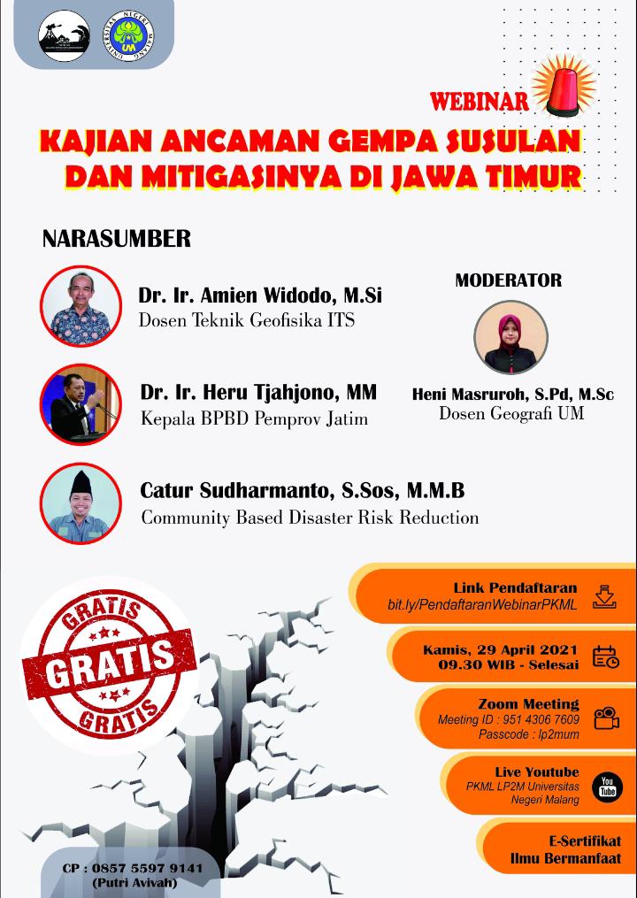
Discussing the Potential of Earthquake Continuation in East Java, Universitas Negeri Malang invites Dr. Amien Widodo as a Webinar Resource Speaker
Information


About the South Malang Earthquake
The M6.1 earthquake in South Malang, which killed 10 people and injured hundreds of people and caused a lot of damage to buildings, turned out to be not the first earthquake but it had been repeated.
Head of the Badan Meterorologi dan Geofisika (BMKG) Malang Karangkates Station, Musripan revealed a number of events that had occurred.
An earthquake measuring 6.7 on the Richter scale occurred on November 20, 1958. The earthquake was felt up to VIII MMI. It should be noted, the MMI VIII intensity scale causes minor damage to buildings with strong construction.
Then, an earthquake measuring 6.2 on the Richter scale occurred on February 19, 1967. This incident damaged 1,900 houses. The worst condition occurred in Dampit District. The strength of this earthquake was felt in Banyumas, Central Java.
The earthquake that caused quite a lot of casualties occurred in the southern route, to be precise in Blitar and Trenggalek. The incident took place on October 4, 1972. The magnitude of the 6 magnitude earthquake caused 250 people to die.
The earthquake was also felt by Malang Regency
3/6/1994
An earthquake occurred in Banyuwangi with an earthquake strength reaching 7 on the Richter scale and the MMI VIII earthquake intensity scale. The earthquake caused disasters in Rajegwesi, Gerangan, Lampon, Pancer, Sempu Island, Grajagan, Pulau Merah, Teluk Hijau, Sukamade, Watu Ulo, Teluk Sipelori and Teluk Tambakan. The effects of the tsunami reached the beaches of Banyuwangi, Jember, Malang, Blitar, Tulung Agung, Trenggalek & Pacitan.
are you curious to know more? Join the webinar held by the Universitas Negeri Malang, with the resource speakers:
- Dr. Amien Widodo (Geophysical Engineering ITS)
- Dr. Ir. Heru Tjahjono, M.M. (Head of BPBD Jatim)
- Catur Sudharmanto (Community Based Disaster Risk Education)
as moderator:
- Heni Masruroh, S.Pd, M.Sc. (Lecturer of Geografi, Universitas Negeri Malang)
Webinar will be held on:
- Time: Thursday, 29 April 2021 | 09.30-drop WIB
- Registration: bit.ly/PendaftaranWebinarPKML
- Join Zoom: 9514306 7609 ; password: lp2mum
- Live Youtube: PKML LP2M Universitas Negeri Malang
#GeophysicalEngineeringITS
#TeknikGeofisikaITS
#FakultasTeknikSipilPerencanaandanKebumianITS
#FacultyofCivilPlanningandGeoEngineeringITS
#InstitutTeknologiSepuluhNopember
Latest News
-
Kuliah Tamu “Bahaya Geologi Penurunan Tanah Daerah Pesisir Pantai Utara Jawa”
Teknik Geofisika ITS menyelenggarakan Kuliah Tamu “Bahaya Geologi Penurunan Tanah Daerah Pesisir Pantai Utara Jawa” dengan mengundang narasumber dari
-
WEBINAR “CERITA SUKSES UGG KEBUMEN & UGG MERATUS”
Teknik Geofisika ITS dan Ikatan Ahli Geologi Indonesia (IAGI) menyelenggarakan webinar “Cerita Sukses UGG Kebumen dan UGG Meratus”, mengundang
-
Beradaptasi dengan Sesar Aktif Penyebab Gempa Darat, Belajar dari Gempa Myanmar
1. Belajar dari Gempa Myanmar Jumat, 28 Maret 2025, pukul 13:20:56 WIB wilayah Mandalay, Myanmar, diguncang gempabumi tektonik. Gempa