Press Release of Webinar “Penurunan Tanah Kabupaten Sidoarjo”, Saturday, 2 July 2022
Information
Land Subsidence Damage and Losses in Sidoarjo Regency
The viral flood incident in Banjarasri Village and Kedungbanteng, Tanggulangin District, Sidoarjo, which has occurred since the end of 2019 and the inundation lasts for more than 20 days and there is no sign of receding. Some residents said that “there was never a flood like this in almost a month”. “So far, even if it rains heavily, there will be puddles the next day it’s dry again.” SDN Banjarasri was inundated by a severe trough with a flood depth of up to 50 cm and the video of the children’s flag ceremony went viral as well as concerning.

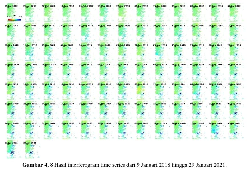
Figure 1 INSAR satellite map of Kedungbanteng and Banjarasri Villages, Tanggulangin District, Sidoarjo. Notice the lower right blue patch getting thicker. There is a date for each image.
The inundation occurred due to land subsidence and has been studied by Arab King Abdullah University Science and Technology (KAUST) students and scientists from Japan. Arifianto and Waluyo 2020 also conducted an INSAR study and the results showed that during the 2019-2020 period, the rate of land subsidence in the mudflow area decreased exponentially in one year. The Tanggulangin and Wunut areas experienced an increase in the rate of land subsidence at the end of 2019. The cause of land subsidence in Tanggulangin is probably due to production activities in the gas field. Josaphat et al in 2021 from Chiba University based on INSAR data showed that in Sidoarjo Regency there were 3 areas that experienced a decline, namely the mud area, Wunut area and Tanggulangin area.

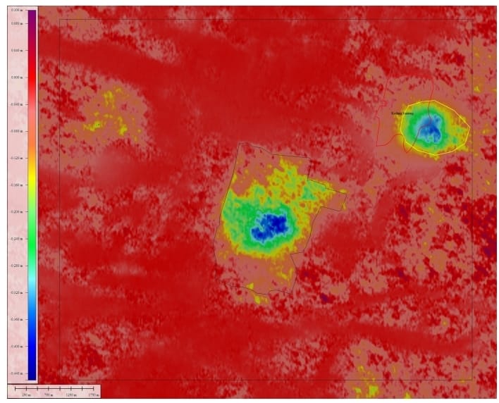
Gambar 2 : Hasil kajian Indra dan Waluyo 2020 berdasar data INSAR sampai April 2020 kawasan Desa Kedungbanteng dan Banjarasri (gambar bulatan kanan atas) mengalami penurunan sampai 40 cm (warna biru gelap).
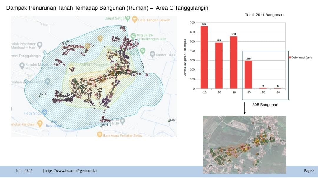
BPBD Kab Sidoarjo melakukan kajian terhadap banjir ini pada akhir 2020 dan dilanjutkan pada pertengahan tahun 2021 bekerjasama dengan DRPM ITS Surabaya. Kajian meliputi kajian penurunan tanah dengan INSAR, pengukuran GPS, Topografi, pengukuran geolistrik, asesmen hidrologi banjir dan asesmen kerugian bencana. Hasil kajian INSAR dan GPS kawasan tersebut mengalami penurunan (subsidence) 20 cm pertahun dan penurunan terdalam 60 cm sehingga kawasan tersebut menjadi cekung dan saat hujan air hujan tergenang (nganthong). Hasil pengukuran GPS dan hidrologi sungai menunjukkan adanya perrubahan morfologi dasar sungai sehingga ada perubahan arah aliran. Hasil pengukuran geolistrik menunjukkan kawasan tersebut tersusun oleh endapan lempung lunak yang tebal dan ada retakan retakan di bawah kawasan yang turun.

Figure 3: The results of a study by BPBD Sidoarjo and ITS show that hundreds of houses were submerged in water due to subsidence in the villages of Banjarasri and Kedungbanteng.
The post-disaster needs assessment, hereinafter abbreviated as Jitupasna, is a series of assessment and impact assessment activities, impact analysis, needs estimation, and initial recommendations for the recovery strategy which forms the basis for the preparation of post-disaster rehabilitation and reconstruction plans. Calculation of the value of damage and loss based on various sectors including the Residential Sector, Infrastructure Sector, Economic Sector, Social Sector and Cross Sector. Based on the results of a quick study of damage and losses due to flooding, it shows that every time a flood occurs, damage and losses reach 100 M.
Andang Bachtiar, secretary general of the Association of Oil and Gas and Renewable Energy Producing Regions (ADPMET) gave his response regarding the possibility if the concentric land subsidence above the Tanggul Angin and Wunut oil and gas fields was caused by the oil and gas production process from within it. The damage and permanent losses due to flooding, which was up to 100 billion rupiahs, were actually far greater than the average profit-sharing obtained by Sidoarjo Regency directly from the gas production business in the 2 fields, which was 2-5 billion rupiahs per year. earn up to 15 billion rupiah at peak gas production in 2019. Andang recommends involving data from the oil and gas industry through SKKMigas and the Directorate General of Oil and Gas in the analysis of the causes of flooding in order to better ascertain the main cause of the disaster that has occurred since 5 years ago.
Andang Bachtiar, secretary general of the Association of Oil and Gas and Renewable Energy Producing Regions (ADPMET) gave his response regarding the possibility if the concentric land subsidence above the Tanggul Angin and Wunut oil and gas fields was caused by the oil and gas production process from within it. The damage and permanent losses due to flooding, which was up to 100 billion rupiahs, were actually far greater than the average profit-sharing obtained by Sidoarjo Regency directly from the gas production business in the 2 fields, which was 2-5 billion rupiahs per year. earn up to 15 billion rupiah at peak gas production in 2019. Andang recommends involving data from the oil and gas industry through SKKMigas and the Directorate General of Oil and Gas in the analysis of the causes of flooding in order to better ascertain the main cause of the disaster that has occurred since 5 years ago.
Eko Teguh Paripurno, lecturer in Disaster Management Masters at UPN Veterans Yogyakarta and Chair of the Gusdurian Peduli Advisory Board, invites all parties to jointly carry out the mandate of the 1945 Constitution, to protect residents from disasters. With regard to the potential loss to citizens, the moratorium on oil and gas exploitation is an option, in line with our obligation to carry out mitigation and emergency response operations. This case should also be a lesson for resource exploitation efforts that have the potential to trigger ecological disasters to apply the precautionary principle more seriously.
Why does this need immediate attention? This is because INSAR data until early 2021 shows the decline is still ongoing until now. No sign of stopping yet. Due to this situation, a detailed study of the causes of the decline is urgently needed. The authority for the study is in the Ministry of Energy and Mineral Resources, especially the Geological Agency, so it is recommended that the Head of the Geological Agency conduct a study of the causes of the decline.

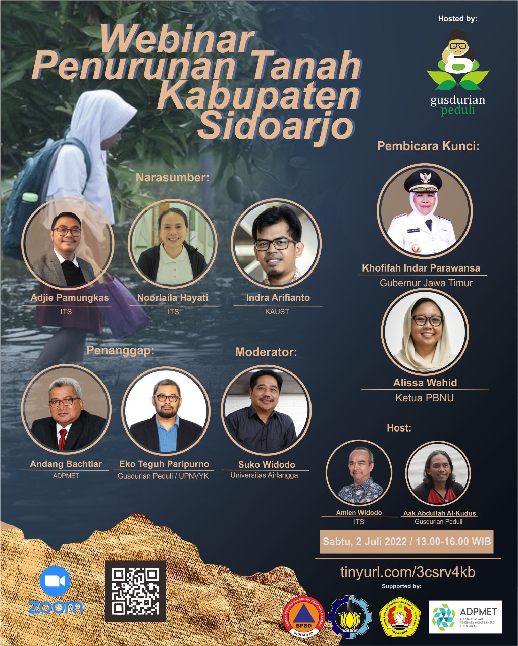
Figure 4: The Sidoarjo Regency Land Subsidence Webinar organized by Gusdurian Peduli
Latest News
-
Kembangkan Deep Nueral Network dan IOT Dalam Carbon Capture Storage, Mahasiswa Teknik Geofisika ITS Sabet Juara 2
Dua Mahasiswa Teknik Geofisika ITS berhasil menjuarai kompetisi nasional INCEPTION 2025. Dimas Xavier Saivascello (5017241010) dan Luvin Diart Lazertino
-
Mahasiswa Teknik Geofisika ITS Sabet Juara 1 Petrowell Study Case Competition
Tiga Mahasiswa Teknik Geofisika ITS berhasil menjuarai kompetisi nasional di bidang Oil & Gas. Tim mahasiswa yang terdiri E.T.A.
-
MITIGASI KOMPREHENSIF BANJIR
Musim hujan datang, selalu ada bencana banjir di berbagai provinsi di Indonesia. Sebagian besar media memberitakan kejadian banjir dimana


