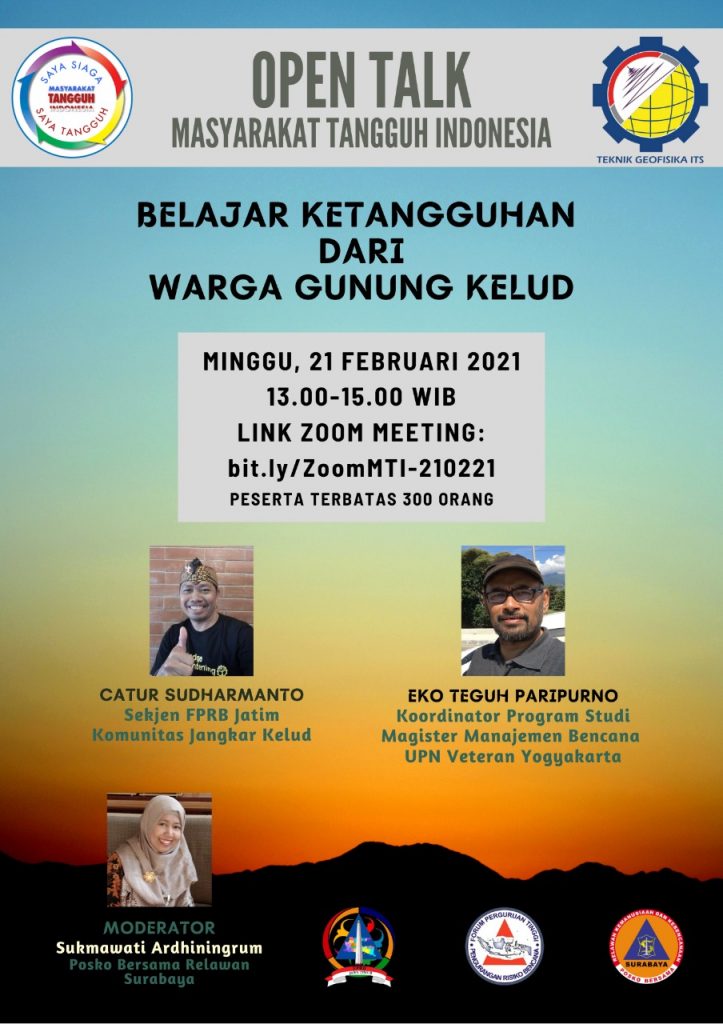
Open Talk-Belajar Ketangguhan dari Warga Gunung Kelud
Information
LEARN HOW THE THOUGHNESS OF MOUNT KELUD CITIZENS
Mount Kelud with an altitude of 1,731 meters above sea level again erupted on Thursday (13/2/2014) night and has spewed the contents of its reservoir, in the form of sand, dust and boulder-sized stones. The change in the status of Mount Kelud which was fast, unlike the previous eruption, caused a stir for many parties. Sunday (2/2) the status changed to Siaga. Monday (10/2) the status went up again from Siaga to Waspada, until finally the eruption occurred on Thursday, 13/2/2014 at night changing the status to Awas, which means tens of thousands of people had to flee with little preparation time.
Thank God, 87,000 people were rescued from the massive eruption. This is the specialty of Disaster Management on the Kelud Slopes, tens of thousands of people on the Kelud slopes were saved. This shows clearly the central role of the community in disaster management. The community, including elements of local government and others, have taken the initiative to carry out disaster management, starting from educating fellow citizens to managing the evacuation and evacuation process.
Some testimonies, for example, were from Mr. Ismuntin (52), a resident of the Dusun / Desa Kebonrejo, Kepung District. Her house is 5 kilometers away, so it is very dangerous to be affected by the eruption. The eruption that occurred at Mount Kelud at this time was truly unexpected. “I have experienced this (eruption) three times, in 1990, 2007, and most recently (2014), but the worst is this 2014,”. He was forced to leave his home, afraid of the wrath of Mount Kelud. When the first sound of the eruption occurred, it sounded like the sound of a bomb exploding and he and his family ran, carrying the makeshift items. Ismutin fled to SDN Siman together with his neighbors. The distance, only about 15 kilometers from the summit of Mount Kelud. Lightning thundered, the sky was pitch black, it didn’t stop. After a while, a splash of hard gravel descended.
Masyarakat Tangguh Indonesia and Geophysical Engineering ITS presents Open Talk BELAJAR KETANGGUHAN DARI WARGA GUNUNG KELUD which invites the practitioner and researcher to give knowledge and also to have a intensive discussion about how was the role of the community when the the 2014 eruption occured.
Webinar Potensi dan Pengolahan Logam Tanah Jarang sebagai Mineral Strategis dan Energi Masa Depan
With Speakers:
- Catur Sudharmanto (Sekjen FPRB Jatim – Komunitas Jangkar Kelud)
- Eko Teguh Paripurno (Koordinator Program Studi Magister Manajemen Bencana UPN Veteran Yogyakarta)
As Moderator:
- Sukmawati Ardhiningrum (Posko Bersama Relawan Surabaya)
This event will be held on:
- Sunday, 21 February 2021 | 13.00 – 15.00 WIB
- Zoom: bit.ly/ZoomMTI-210221

#GeophysicalEngineeringITS
#TeknikGeofisikaITS
#FakultasTeknikSipilPerencanaanDanKebumianITS
#FacultyofCivil,PlanningAndGeoEngineeringITS
#InstitutTeknologiSepuluhNopember
Latest News
-
Kembangkan Deep Nueral Network dan IOT Dalam Carbon Capture Storage, Mahasiswa Teknik Geofisika ITS Sabet Juara 2
Dua Mahasiswa Teknik Geofisika ITS berhasil menjuarai kompetisi nasional INCEPTION 2025. Dimas Xavier Saivascello (5017241010) dan Luvin Diart Lazertino
-
Mahasiswa Teknik Geofisika ITS Sabet Juara 1 Petrowell Study Case Competition
Tiga Mahasiswa Teknik Geofisika ITS berhasil menjuarai kompetisi nasional di bidang Oil & Gas. Tim mahasiswa yang terdiri E.T.A.
-
MITIGASI KOMPREHENSIF BANJIR
Musim hujan datang, selalu ada bencana banjir di berbagai provinsi di Indonesia. Sebagian besar media memberitakan kejadian banjir dimana


