SENOPATI, Inovasi Instrumen Pendeteksi Dini Tsunami oleh Peneliti Teknik Geofisika ITS
Information
Indonesia is one of the countries categorized as a country with a high level of vulnerability to tsunami disasters. In response to this phenomenon, three geophysicists from the Sepuluh Nopember Institute of Technology (ITS) from the Department of Geophysics Engineering designed a tsunami early detection instrument by utilizing the principle of wave reflection.

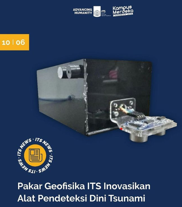
Instrument visualization of SENOPATI (source: instagram @its_campus)
The three experts are Dr. Ir Amien Widodo MSi, Juan Pandu Gya Nur Rochman SSi MT, and Kharis Aulia Alam ST. The tool designed by the three experts was named SENOPATI which stands for Ten November Tsunami Early Detection. However, the use of this tool is still limited to a laboratory scale (it has not been used directly).
Speaking further about the research, Amien said that SENOPATI works by using the principle of wave reflection, where the height from the water level can be measured by sensors to detect the arrival of a tsunami. “Because the tsunami caused the sea water to recede, so we see if there is low tide at a certain time it is a sign of an early warning of a tsunami,” said Amien.
The senior researcher from the Research Center for Disaster Mitigation and Climate Change (Puslit MKPI) ITS added that the principles used in wave reflection were applied in two sensors, namely ultrasonic sensors and Doppler sensors. Ultrasonic waves themselves are able to get the distance of the wave reflector by using the Time of Light or ToF principle (the method used to measure the distance between the sensor and the object).
Meanwhile, the Doppler sensor utilizes ultrasonic waves that are fired at the object and then calculates the frequency shift received as the value of the speed of the moving object. “So if the water level recedes quickly, this tool will tell you that there will be signs of a tsunami,” said the 62-year-old man.

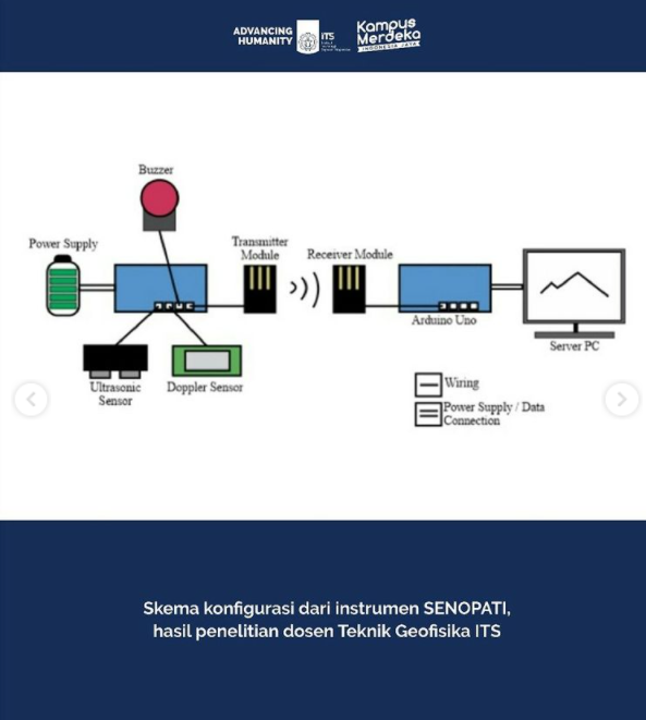
Instruments Configuration of SENOPATI (source: instagram @its_campus)
Regarding how SENOPATI works, according to Amien, if a rapid decrease in water level is identified, the device will display a red color and the buzzer will light up sending an evacuation warning. In this study, the receding velocity parameter still uses synthetic values that adjust the size of the test model used. That is, the trial model has not used the original value of events in the field.
Amien said, this research has been going on since 2019 and continues to be developed until now. The purpose of this instrument design is to make a tsunami detector that is easy to apply and inexpensive. “Indonesia basically has a tsunami early detection system called Buoy. Unfortunately, the current condition of the instrument is lost or damaged due to the actions of irresponsible people,” he explained.
Because the design of the tool is still limited to the laboratory scale, Amien explained if the constraints or shortcomings that exist in SENOPATI still do not show significant problems. From Amien’s information, evaluation of SENOPATI will continue to be carried out in line with development and if the tool can be applied directly in the field or on the high seas.
In the future, this Geophysical Engineering Department lecturer hopes that SENOPATI can be included in the scope of more detailed research by ITS and can get further funding. “We also want to make a better prototype and we tested it with a larger size so we can know the reliability of this tool,” concluded Amien.
Latest News
-
Kembangkan Deep Nueral Network dan IOT Dalam Carbon Capture Storage, Mahasiswa Teknik Geofisika ITS Sabet Juara 2
Dua Mahasiswa Teknik Geofisika ITS berhasil menjuarai kompetisi nasional INCEPTION 2025. Dimas Xavier Saivascello (5017241010) dan Luvin Diart Lazertino
-
Mahasiswa Teknik Geofisika ITS Sabet Juara 1 Petrowell Study Case Competition
Tiga Mahasiswa Teknik Geofisika ITS berhasil menjuarai kompetisi nasional di bidang Oil & Gas. Tim mahasiswa yang terdiri E.T.A.
-
MITIGASI KOMPREHENSIF BANJIR
Musim hujan datang, selalu ada bencana banjir di berbagai provinsi di Indonesia. Sebagian besar media memberitakan kejadian banjir dimana


