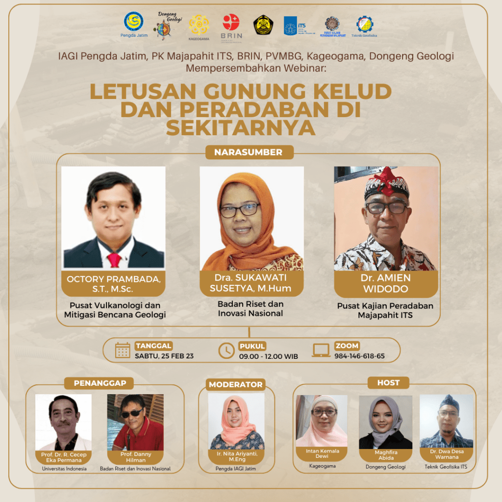
WEBINAR Letusan Gunung Kelud dan Peradaban di sekitarnya
Information
PVMBG stated that the eruption of Mount Kelud had occurred repeatedly, starting in 1000 until now. The character of the eruptions in 1901 and 1919 was almost the same which was marked by several earthquakes followed by very loud bangs that could even be heard far away and also followed by a roar from the direction of Mt. Kelud. The character of the eruption begins with the throwing of water from the crater lake about 38 million m3 before the eruption. The solid material ejected during the eruption was approximately 200 million m3. The lava that is formed is primary lava that occurs directly by the crater lake water which is a mixture of hot water, mud, sand and rocks which will become a devastating flash flood. The speed of the lava flowing in the city of Blitar is around 18 m/s or around 65 km/hour. The maximum distance of the primary lava flow reaches 37.5 km (calculated from the top of Kelud). In 1924, drainage of the crater water began with tunnels so that the remaining crater water would not cause lava floods. The next eruption with the same sign but not followed by a flood of hot lava.
The character of the eruption of G. Kelud in the 10th – 15th centuries was the same as before the crater water tunnel engineering. This is well recorded in the records of Pararaton, Negara Kertagama and other fibers. Dwi Cahyono, 2012 states that in Serat Pararaton there are at least eight sections (VIII, IX, X, XI, XII, XIV, XVII, XVIII) containing information on volcanic events which call it the term “thunder”. with rocks and lava, from volcanic eruptions), or it could mean a roaring mountain river (Zoetmulder 1995:318, in Dwi Cahyono 2012).
The enormity of the sound of a volcano erupting is also called “thunder”, while the eruption is referred to as “agra thunder”. This word element is also used to refer to natural physical elements associated with volcanoes such as a very swift mountain river (lewu guntur), whose thunderous water flows down (thunder). Volcanic eruptions are often accompanied by floods (cold lava or hot lava). In part X it contains: Tunulu hana gunung anyar i saka saka naga – leng – karnaning – wong, 1298 (then the emergence of a new mountain child occurred in the year of saka snake – liang – ear – orang or 1298 or 1376M). Tumuli Guntur pamadisha i sak resi – sunya – guna – single (1307 or 1385 M when G. Kelud erupted).
Furthermore Dwi Cahyono, 2012 mentions that in Nāgarakṛtāgama describes volcanic phenomena in more detail and even dramatically, with the words “earthquake” (liṇḍu), earthquake or earth shaking (bhumi kturg), rain of dust (hudan hawu), rumble (gĕṛḥ), thunder or lightning continued in the sky (kilat awiltan ing nabhastala), rumble (thunder) the sound of a volcano (himawān) vibrated. A number of other literatures which describe volcanic eruptions are in Rāmāyana (19.54), Arjunawiwaha (19.6, 19.10, 21.14), Bhomakawya (64.5), Arjunawijaya (8.10), Sutasoma (51.4, 73.12, 79.8) and Song of Harsyawijaya (49.20).
ECJ Mohr (1938), a Dutch agricultural expert, said that volcanoes are fertile areas because they can store rainwater and always emit and regenerate soil through ash rain for a certain period. Volcanic areas everywhere will be visited by humans so that many civilizations around the volcano. Likewise many civilizations around G. Kelud such as Majapahit and centuries before. Currently this civilization was buried by the eruption of Mount Kelud in the past.
We, the ITS Majapahit Civilization Study Center, Geological Tales, Kageograma and IAGI Pengda East Java will be holding a Webinar “The Eruption of Mount Kelud and the Surrounding Civilizations” to provide additional insight to the community and stakeholders so they understand how powerful volcanic activity was in the past and can repeated in the future.
With Resource Speakers:
- Octory Prambada S.T., M.Sc. (Pusat Vulkanologi dan Mitigasi Bencana Geologi)
- Sukawati Susetyo, M.Hum (Pusat Riset Arkeologi Prasejarah dan Sejarah BRIN)
- Dr. Amien Widodo (Teknik Geofisika ITS)
As Responders:
- Prof. Cecep Eka Permana (Departemen Arkeologi, Fakultas Ilmu Bahasa UI)
- Prof. Danny Hilman (BRIN)
As Moderator:
- Nita Ariyanti, M.Eng
As Host:
- Intan Kemala Dewi (Kageogama)
- Maghfira Abida (Dongeng Geologi)
- Dr Dwa Desa Warnana (Teknik Geofisika ITS)
Come join us on:
- Saturday 25 February 2023
- 09.00 – 12.00 WIB
- Zoom : https://its-ac-id.zoom.us/j/98414661865

Latest News
-
MITIGASI KOMPREHENSIF BANJIR
Musim hujan datang, selalu ada bencana banjir di berbagai provinsi di Indonesia. Sebagian besar media memberitakan kejadian banjir dimana
-
Webinar PEMETAAN BENCANA
Departemen Teknik Geofisika ITS menyelenggarakan Webinar dengan topik “PEMETAAN BENCANA” mengundang para pakar: Opening Speech : Dr. Farida Rachmawati,
-
Guest Lecture “Real-Time Data Standard for Drilling Operations“
Perusahaan eksplorasi dan produksi minyak dan gas dapat menjaga margin keuntungan yang stabil dengan memanfaatkan data real-time dalam pemantauan


