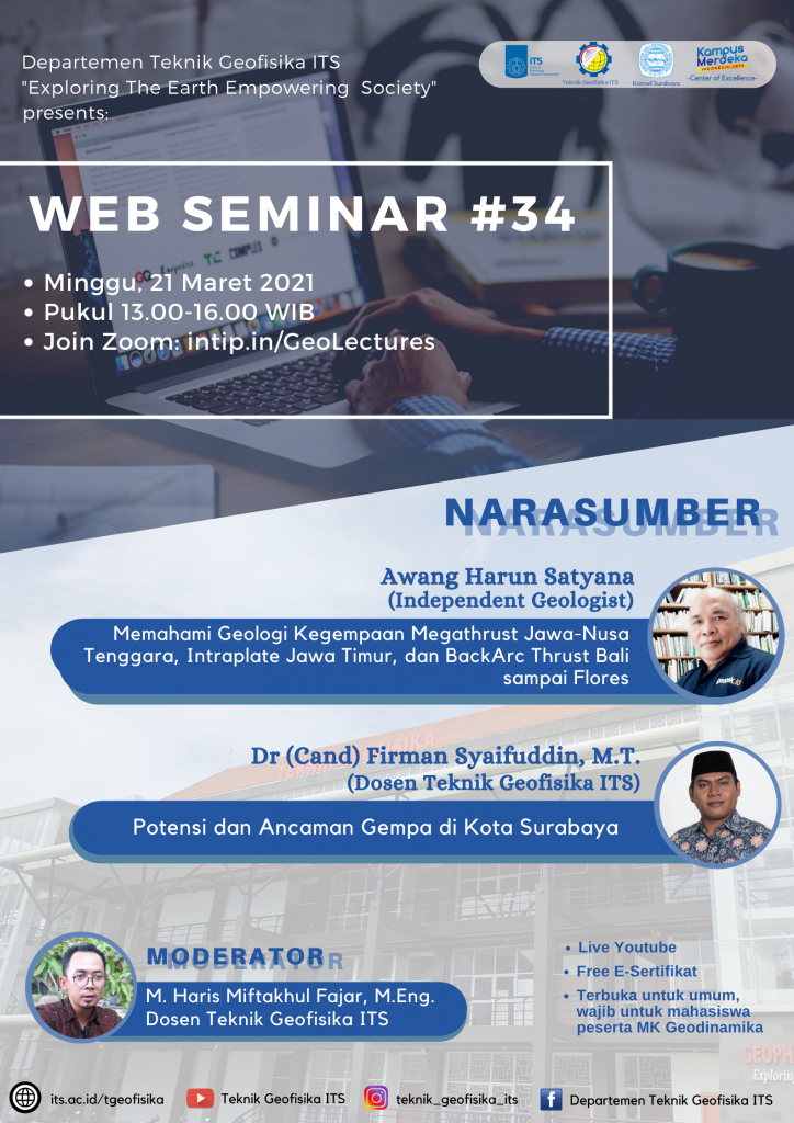
Webinar#34 Memahami Geologi Kegempaan Megathrust Dan Sesar Aktif
Information
The Java to Flores region is a region with high seismicity. Earthquakes on land and sea, some of which were accompanied by tsunamis, have occurred in this area. As a densely populated area, it is important to continue to carry out and improve mitigation of the earthquake and tsunami.
Due to their geological and tectonic positions, the Java to Flores regions have different seismic characteristics. There are earthquakes related to plate subduction / megathrust in southern Java-Bali-Nusa Tenggara, earthquakes that activate old faults in the middle of the East Java plate / intraplate, earthquakes related to the infiltration of the transitional crust on the Sundaland edge and the Banda ocean crust under the volcanic arc / back-arc thrust Bali-Lombok-Sumbawa-Flores.
The results of the 2017 PUSGEN study, East Java Province, contained many faults, such as the Wonorejo Fault in Banyuwangi Regency, the Probolinggo Fault in Probolinggo Regency, and the Pasuruan Fault in Pasuruan Regency. The city of Surabaya is passed by 2 faults, namely the Surabaya Fault and the Waru Fault. The Waru fault extends through Gresik, Mojokerto, Jombang Nganjuk and Saradan.
ITS took the initiative to research faults that pass through the city of Surabaya with geophysical and geotechnical approaches. The result is that the source area of the earthquake (fault plane) is seen extending westward up to 64 km, a depth of 0-11 km and a slope of 54 °.
Understanding the geology and tectonics of the variations in the origin of this earthquake can improve the quality of mitigation efforts so that the potential victims of the earthquake-tsunami disaster in this area can be reduced.
Therefore, Geophysical Engineering ITS in collaboration with HAGI Komwil Surabaya proudly presents a webinar:
With The Speakers:
-
Awang Harun Satyana (Memahami Geologi Kegempaan Megathrust Jawa-Nusa Tenggara, Intraplate Jawa Timur, dan BackArc Thrust Bali sampai Flores)
- Dr (Cand) Firman Syaifuddin, M.T. (Potensi dan Ancaman Gempa di Kota Surabaya)
and Moderator:
- M. Haris Miftakhul Fajar, M.Eng (Lecturer of Geophysical Engineering ITS)
The event will be held on:
- Sunday, 21 March 2021
- 13.00-16.00 WIB
- Join Zoom: intip.in/GeoLectures
- Live Youtube: Teknik Geofisika ITS
This webinar is open for public, and is a must for Geophysical Engineering students who are participants of Geodinamic course.
Presentation of speakers can be accessed through these links:
- Memahami Geologi Kegempaan Megathrust Jawa-Nusa Tenggara, Intraplate Jawa Timur, dan BackArc Thrust Bali sampai Flores
- Potensi dan Ancaman Gempa di Kota Surabaya
Join and get the free e-certificate!

#Geophysical Engineering ITS
#Teknik Geofisika ITS
#Fakultas Teknik Sipil Perencanaan dan Kebumian ITS
#Faculty of Civil, Planning and Geo Engineering ITS
#Institut Teknologi Sepuluh Nopember
Latest News
-
Kembangkan Deep Nueral Network dan IOT Dalam Carbon Capture Storage, Mahasiswa Teknik Geofisika ITS Sabet Juara 2
Dua Mahasiswa Teknik Geofisika ITS berhasil menjuarai kompetisi nasional INCEPTION 2025. Dimas Xavier Saivascello (5017241010) dan Luvin Diart Lazertino
-
Mahasiswa Teknik Geofisika ITS Sabet Juara 1 Petrowell Study Case Competition
Tiga Mahasiswa Teknik Geofisika ITS berhasil menjuarai kompetisi nasional di bidang Oil & Gas. Tim mahasiswa yang terdiri E.T.A.
-
MITIGASI KOMPREHENSIF BANJIR
Musim hujan datang, selalu ada bencana banjir di berbagai provinsi di Indonesia. Sebagian besar media memberitakan kejadian banjir dimana


