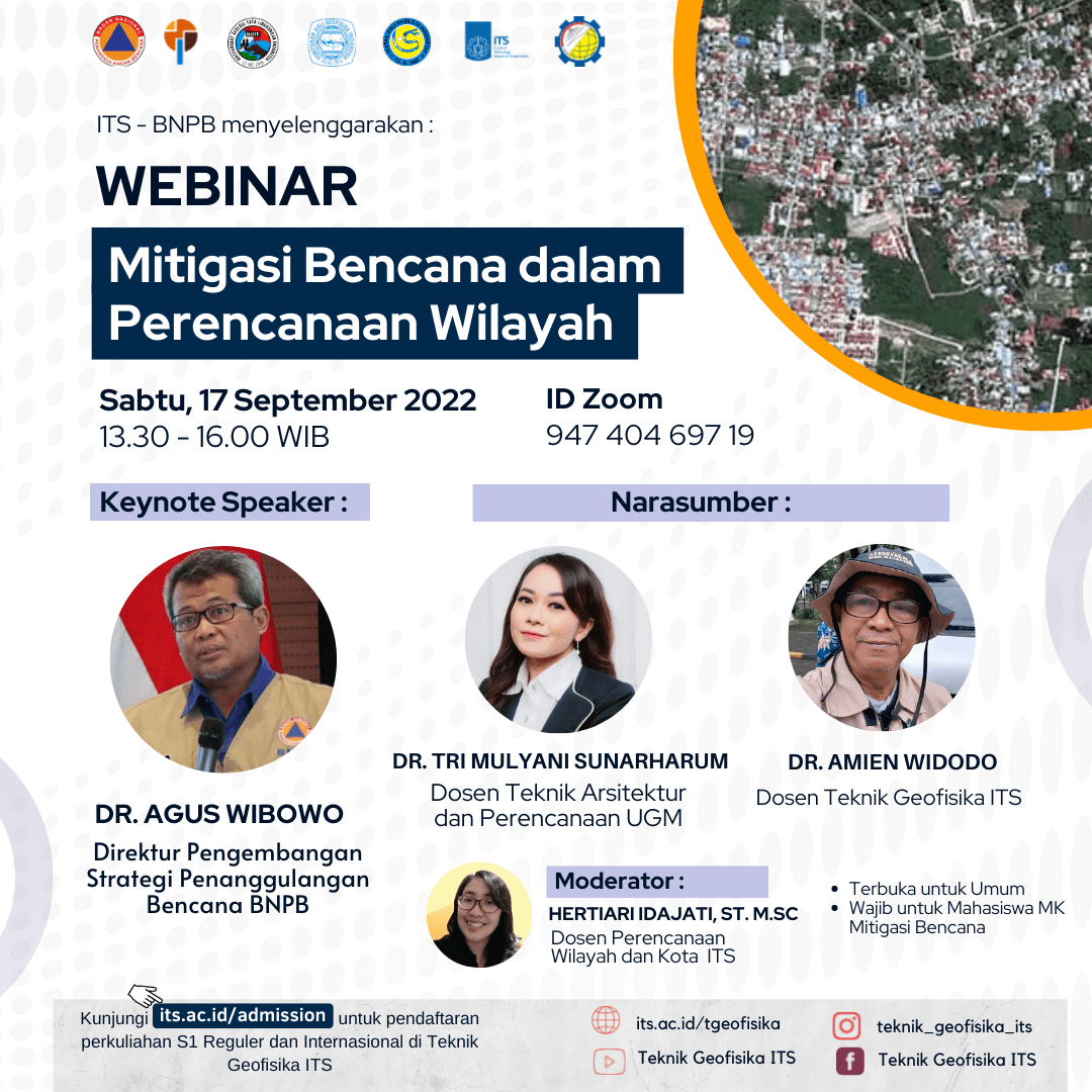
WEBINAR#61 “Mitigasi Bencana dalam Perencanan Wilayah”
Information


The Indonesian people live in areas of active plate collision and in tropical climates. This means that we live in areas prone to earthquakes, tsunamis, liquefaction, volcanic eruptions, landslides, etc. At the same time we live in the equatorial region, there is a lot of rain, wind, heat, high tides, big waves, etc. that occur for months per year. Phenomena of el nino, la nina, tropical cyclones etc., which provide additional rain and additional heat for Indonesia.
These natural occurrences have been going on for a long time and repeat themselves with the same strength, return period, location, path. As part of the dynamics of the earth that must occur. Currently, climate change is increasing hydrometeorological threats such as triggering floods, landslides, flash floods, hurricanes, extreme waves and coastal abrasion.
This nation must adapt and continuously carry out mitigation actions, both structural mitigation and non-structural mitigation so that disaster risk can be reduced.
The data states that a total of 1,183 people die per year due to disasters in the last 10 years. The head of the National Disaster Management Agency (BNPB) (2021), stated that Indonesia suffered economic losses due to disasters an average of IDR 22.8 trillion per year. This means that every year there is a diversion of productive funds to be diverted to disaster management.
In accordance with the mandate of President Joko Widodo to synergize all stakeholders in preventing and mitigating disasters through sustainable regional planning. Through disaster mitigation, it is hoped that it will become an important investment and become one of the approaches in regional planning and development.
Departmen of Geophysical Engineering, Faculty of Civil, Planning, and Geo Engineering, Institut Teknologi Sepuluh Nopember Surabaya, in collaboration with BNPB, UGM, MAGETI, HAGI, IAGI, PP MKPI presents a webinar to share experiences, good practices and formulate future recommendations related to disaster mitigation in regional planning.
Invited resource speakers:
- Dr Agus Wibowo (Director of Pengembangan Strategi Penanggulangan Bencana BNPB)
- Dr Tri Mulyani Sunarharum (Lecturer of Teknik Arsitektur dan Perencanaan Wilayah UGM)
- Dr Amien Widodo (Lecturer of Teknik Geofisika ITS)
As moderator:
- Hertiari Idajati, S.T., M.Sc. (Dosen perencanaan Wilayah dan Kota ITS)
Note the date :
 Saturday, 17 September 2022
 13.30-16.00 WIB
 Zoom webinar : https://zoom.us/j/94740469719
The presentation of speaker can be accessed here
Latest News
-
Pertajam Keilmuan Petrofisikamu dengan Studi Kasus Di Dunia Oil and Gas, dalam PETROPHYSICS TRAINING 2025!
Teknik Geofisika ITS mengajak anda untuk mendalami pengetahuan dan masalah-masalah yang terjadi seputar Petrofisika dalam acara PETROPHYSICS TRAINING 2025.
-
Kuliah Tamu “Bahaya Geologi Penurunan Tanah Daerah Pesisir Pantai Utara Jawa”
Teknik Geofisika ITS menyelenggarakan Kuliah Tamu “Bahaya Geologi Penurunan Tanah Daerah Pesisir Pantai Utara Jawa” dengan mengundang narasumber dari
-
WEBINAR “CERITA SUKSES UGG KEBUMEN & UGG MERATUS”
Teknik Geofisika ITS dan Ikatan Ahli Geologi Indonesia (IAGI) menyelenggarakan webinar “Cerita Sukses UGG Kebumen dan UGG Meratus”, mengundang