Site Map
Copyright © 2025 Institut Teknologi Sepuluh Nopember

Activities that aim to socialize the field of Survey and Mapping or Geodesy Engineering at ITS continue to be carried out including in the form of seminars, scientific meetings, congresses, education/training and so on; Some of the activities that have been taken include :
The active role of lecturers specializing in ITS Geodetic Engineering in professional organizations in Indonesia such as ISI (Indonesian Surveyor Association), MAPIN (Indonesian Remote Sensing Society), ISGI (Indonesian Geodetic Bachelor Association), MAPETA (Mapping Society), DGI (Geomatics Council) Indonesia) and PII (Indonesian Engineers Association) and abroad such as IAG (International Association of Geodesy) and ISPRS (International Society of Photogrammetry and Remote Sensing) both as members and administrators continue to be pursued. Some lecturers continue their doctoral studies in Europe, such as at Univ. Paul Sabatier and l’Université de Nice-Sophia France and Univ. Hannover – Germany.
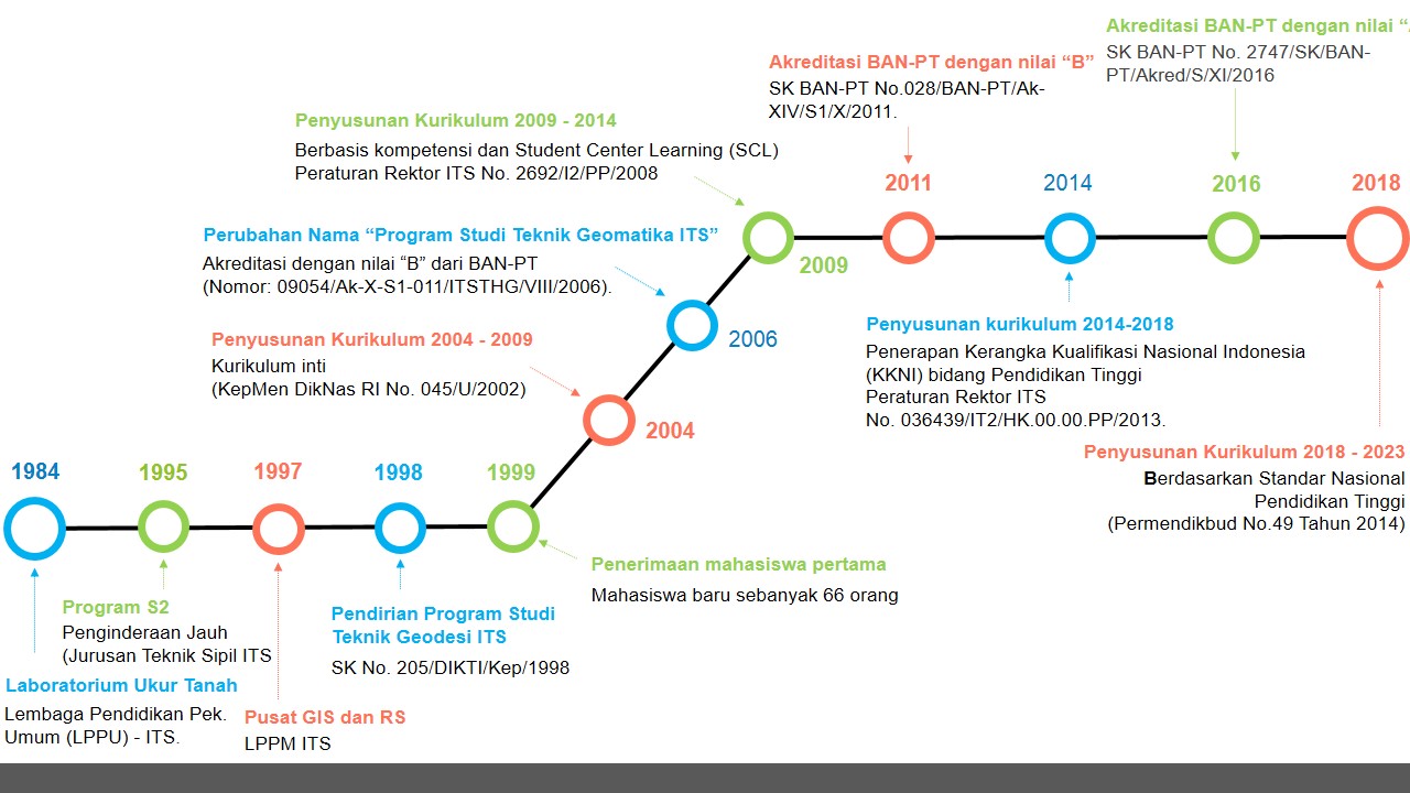
From the activities above, it shows the efforts to introduce Geodesy Engineering in general and to the public both in ITS and outside ITS. Which despite many obstacles and limitations that must be resolved both internally at ITS itself and after the process of introduction and efforts have been made for more than 15 years since it was announced, then in March 1998, the proposed Geodetic Engineering Study Program for the Bachelor Program (S -1) has been proposed by ITS to the Department of Education of the Ministry of National Education.
And on June 24, 1998, after waiting for approximately 3 months, the Geodetic Engineering Study Program was finally officially realized with the issuance of Decree No. 205 / DIKTI / Kep / 1998 dated June 24, 1998.
CHANGING TO GEOMATICS ENGINEERING
Nowadays geodetic science is not only talking about the shape and size of the earth, but also geospatial information technology. Therefore it cannot be denied, that the emergence of the GEOMATIC era is inseparable from the urgent need of modern society to solve problems simultaneously, quickly, correctly, efficiently and actually from all the factors that influence the system, so that optimal results are obtained. This era was driven by the birth of information technology in the 1960s, which has pushed science and technology in the field of surveying and mapping as well as geodesy to develop drastically, because data processing and mapping systems in the field completely use automated or computer technology, this is what drives the emergence geodetic discourse into science and technology “GEOMATICS”. In Canada and the United States, GEOMATICS has been developed in the direction of agrarian / cadastral and tax, known as the Land Information System (LIS).
To face these challenges, the Geodetic Engineering Study Program has identified various factors including :
With the above background and supported by human resources (HR) in the Geodesy Engineering Study Program – FTSP ITS which has 14 lecturers with various specializations, al. Geodesy, Geomatics (Digital Mapping, Digital Photogrammetry, GIS and Remote Sensing), Hydrography and Land with a doctoral (S-3) doctoral degree (S-3) composition (3 Prof), Masters (S-2) are 11 people (6 lecturers currently studying further to level S-3) then submit a name change. The name GEOMATICS ENGINEERING was finally chosen after being approved by the ITS Senate.
After going through several stages ranging from internal proposals to sharing through discussions with several stakeholders to the Institute Senate meeting which took approximately one year, the Geodetic Engineering Study Program was officially held based on Decree No. 205 / DIKTI / Kep / 1998 dated June 24, 1998 changed itself on April 21, 2006 to the Geomatic Engineering Study Program with ITS Chancellor’s Decree No. 2029.1 / KO3 / PP / 2006